
Earth observation solutions for environmental monitoring of industrial port zones (2020 – 2022)
Human activities and the maritime industry can have a considerable impact on ecosystems by modifying coastal dynamics and weakening natural habitats of great ecological value.
Many actors in the industry voluntarily adhere to environmental certification programs to improve their environmental performance. While in-situ monitoring methods have limitations in terms of spatial coverage, advancements in satellite remote sensing, artificial intelligence, and big data processing offer promising solutions for monitoring coastal areas.
The Canadian Space Agency, as part of the SmartEarth initiative, has funded Arctus’project in partnership with the Port of Sept-Îles, represented by the Centre d’expertise industrialo-portuaire, a division of the Institut nordique de recherche en environnement et santé au travail (INREST) to implement an Earth observation (EO) monitoring system for industrial port zones. The system aims to deliver EO products to end-users on a daily to bi-weekly basis and complement in-situ observations.
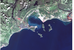
The Bay of Sept-Îles (BSI) is a subarctic coastal environment hosting a major ore-handling port. The bay’s geomorphological configuration and seven-island archipelago provide natural protection, making it an ideal location for port infrastructure. The BSI is known for its rich marine ecosystems, which necessitate monitoring and predicting potential environmental changes.
The project prioritizes parameters such as turbidity, Total Suspended Sediment (TSS), Color Dissolved Organic Matter (CDOM), Chlorophyll-a, Sea Surface Temperature, and key coastal habitats for inclusion in the EO processing chain. Multiple sensors, including satellites from the European Space Agency (ESA) and Landsat, are used to ensure temporal and spatial coverage. Data from these sensors are processed using masking algorithms to remove clouds, cloud shadows, and ice. Atmospheric correction is applied, and dedicated models are used to generate water quality parameters.
The processing chain is implemented in ESA’s Coastal Thematic Exploitation Platform (C-TEP), which provides access to a large volume of structured EO data, processing software, services, algorithms, and computing resources.
A web portal is used to quickly display and disseminate EO products to end-users, enhancing their monitoring capacity and potentially reducing response delays. The system based on cloud services for environmental management contributes to expanding databases of existing observatories and provides additional value-added information to support port authorities and end-users in improving their environmental performance and maintaining their environmental certifications.