
AI4SDB – Satellite-derived bathymetry project (2020 – 2022) and (2023 – 2025)
Coastal environments are among the most dynamic and vulnerable ecosystems on our planet. In the face of climate change and increasing urbanization, coastal mapping plays a crucial role in monitoring erosion, managing flood risks, preserving marine habitats, and ensuring maritime safety. To address these challenges, accurate and regularly updated bathymetric data is essential.
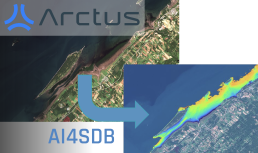
Leveraging Earth Observation technologies, satellite-derived bathymetry is revolutionizing underwater data collection by enabling access to remote and difficult-to-survey areas. Our project harnesses the latest advancements in artificial intelligence, particularly deep learning, to enhance depth estimation and improve the accuracy of bathymetric maps.
We have developed an innovative approach based on deep neural networks and time-series analysis of Sentinel-2 multispectral imagery (10-meter resolution). This method consists of two complementary models:
- A classification model that differentiates optically shallow waters from deeper areas.
- A regression model that accurately estimates water depth in optically shallow zones.
This project has enabled the Arctus team to develop robust and adaptable satellite-based bathymetry solutions. Our tools make it possible to estimate coastal water depth without prior in situ data, paving the way for more efficient and accessible marine monitoring.